History and information about De Haarlemmermeer
Haarlemmermeer: Haarlem is a city and meer means
lake: the lake of Haarlem.
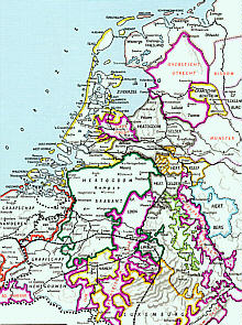 This
is a map of The Netherlands in the year 1350. As you can see, a great part
of Holland consists of water. In these days there were two dangerous lakes
/ seas: the Zuiderzee and Haarlemmermeer. The Haarlemmermeer was a very
dangerous lake between the cities of Haarlem, Leiden and Amsterdam, as
you can see on the map at the right.
This
is a map of The Netherlands in the year 1350. As you can see, a great part
of Holland consists of water. In these days there were two dangerous lakes
/ seas: the Zuiderzee and Haarlemmermeer. The Haarlemmermeer was a very
dangerous lake between the cities of Haarlem, Leiden and Amsterdam, as
you can see on the map at the right.
The nickname of the Haarlemmermeer was WATERWOLF: it engulfed
many villages. During the centuries it became bigger and bigger. Other
lakes like Oude Haarlemmermeer, Leidse meer and Spiering meer became a
part of it. Many ships wrecked in the east part of this lake. This part
was known as the hole of the Waterwolf, a grave for ships. The Dutch meaning
of ship is schip; a hole in Dutch is hol. Nowadays on the cemetery of the
ships from the past is our mean airport situated: Schiphol. Of course we
hope that the airships will have a safer passage then the ships from the
past...
The Waterwolf became very dangerous. So they made plans to
dim the lake. In 1641 Jan A. Leeghwater wrote a book called Haarlemmermeerboek.
His plan was to build 166 windmills which could pump the water away and
drain Haarlemmermeer. But his plan could not be carried out.
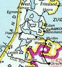
In 1645 De Haarlemmermeer had an area of 15.030 hectares;
in 1740 was it 16.540 and during the first part of the 19th century it
was 18.539 (see the map on the right).
In 1836 the water stood in the streets of Amsterdam and Leiden
and the situation became very dangerous. Would the waterwolf swallow up
these cities too?
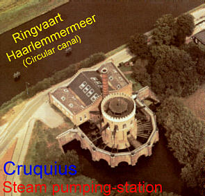 King
Willem I decided that the Haarlemmermeer had to be dimmed. In 1845 they
started the giant job; for the first time in history they used steammachines
to pump the water away. They build three steammachines; one of them, the
Cruquius became a museum in 1934. It endured until 1852 when the job was
finished. Around the Haarlemmermeer they made a dike with a circular canal.
I hope that my drawing will explaine the function of the dikes.
King
Willem I decided that the Haarlemmermeer had to be dimmed. In 1845 they
started the giant job; for the first time in history they used steammachines
to pump the water away. They build three steammachines; one of them, the
Cruquius became a museum in 1934. It endured until 1852 when the job was
finished. Around the Haarlemmermeer they made a dike with a circular canal.
I hope that my drawing will explaine the function of the dikes.
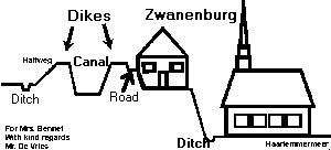
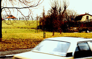
Because the Haarlemmermeer used to be a giant lake, you can
imagine that this part of Holland is beneath sealevel. Our main airport,
Schiphol is situated 6 metres beneath sealevel; Zwanenburg is about 5 metres
beneath sealevel. You can see this at the photo at the left. In front there
is a car driving. At the right of the photo you see a house in the grassland.
Behind the trees you see the dike of Zwanenburg. If you take a closer look,
you can see at the right a house "on the dike". Near this house
you can see (very small) pollard willows.
The difference in height between the street where the car
drives (in Zwanenburg) and the top of the dike is about 5 metres.
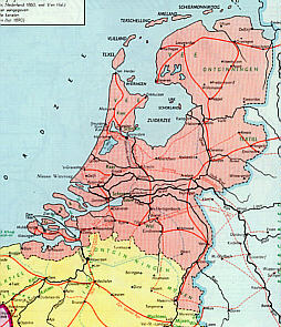
The satellite photo on the right was taken in 1985.
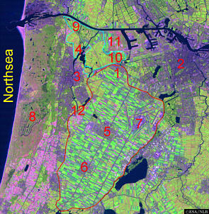
1 - Zwanenburg
2 - Amsterdam
3 - Haarlem
4 - Spaarndam (read the story of Hans Brinker)
5 - Hoofddorp (town in the middle of Haarlemmermeer)
6 - Nieuw-Vennep
7 - Schiphol, our main airport. The people in the cities around Schiphol have much trouble from the airplanes. On this very moment, Schiphol wants to expand their capacity of flights. Our pupils made reports about how they feel about these plans of Schiphol. You can read their reports (in Dutch).
8 - Dunes
9 - Northen part of Spaarnwoude (see our excursion to Zorgvrij)
10 - South part of Spaarnwoude (read our report about this
area)
11 - Ruigoord, a village which must be sacrificed to dig
new harbours
12 - Cruquius
The red line / drawing is the border of Haarlemmermeer.
The cyan line / drawing is the border of Spaarnwoude.
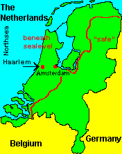 On
this map you can see what could happen if the sea rises (melting of the
North- and Southpole) or if the dunes and dikes won't stand any longer.
On
this map you can see what could happen if the sea rises (melting of the
North- and Southpole) or if the dunes and dikes won't stand any longer.
Visitors since March 28, 1997: 264 + 
© René
de Vries